Monday, November 19, 2018

Irish Plant Carnivores


Round-leaved Sundew aka Common Sundew (Drosera rotundifolia), Killarney National Park. The leaves bear numerous modified stalks or "tentacles" tipped with clear droplets of sticky dew giving rise to the common name.

Not surprisingly, Charles Darwin made the first scientific study of carnivorous plants.  He began his 1875 pioneering work, entitled the "Insectivorous Plants", with a detailed examination of Drosera rotundifolia (pictured above).  Perhaps the most widespread of Ireland's 3 native Sundew (Drosera species), Darwin stated, "it was soon evident that Drosera was excellently adapted for the special purpose of catching insects." And further, "As this plant is extremely common in some districts, the number of insects thus annually slaughtered must be prodigious"!

All Sundew species included here (and studied by Darwin) share similar characteristics.  Each has leaves that appear reddish due to the presence of numerous stalked glands (or modified hairs). The stalks produce clear, sticky "dew".  The gland tipped stalks (which Darwin referred to as "tentacles") are typically longer and, perhaps, more concentrated on the leaf margins. Presumably this provides a larger trapping zone to aid in capturing prey. Much shorter stalks are found in the center of the leaves (see image below). Darwin found that stimulating a single tentacle (such as with a small piece of meat) caused it to bend inward, while the others nearby remained upright.  However, when the meat reached the leaf itself adjacent tentacles often "pour forth an increased amount of secretion" that becomes highly acidic.  Overall, Darwin believed, "the absorption of animal matter from captured insects explains how Drosera can flourish in extremely poor peaty soil".  
Round-leaved Sundew (Drosera rotundifolia) with digested prey remains at Bray Head, Ireland. The blackened insect remnants no longer produce enough stimulus to keep the tentacles pressing inward; according to Darwin these remnants will "be blown away by a breath of air" and the stalks will then re-secrete dew and be ready to clasp a new object once a new droplet of dew has formed. 

Drosera rotundifolia is the smallest of Ireland's sundews, and Great Sundew (Drosera anglica) is the largest. As the images below show, Great Sundew's leaves are much more elongated, to approximately 1" in  length, but share similar "tentacle" characteristics including the lengthier gland-tipped stalks around the margins, and reduced stalks mid-leaf. 
Great Sundew (Drosera anglica) with captured and partially digested prey. The longer stalks along the top of the leaf are bent downward and inward holding the prey, and bringing the item into contact with the smaller glands on the leaf front surface which are believed to produce digestive enzymes (See Lloyd, 1942, Carnivorous Plants). 
Great Sundew (Drosera anglica) with captured Mayfly. Unlike the previous image, the Mayfly is held against the back of the leaf, and digestion may not be possible due to the lack of necessary glands along this surface.

Great Sundew (Drosera anglica) - Note: back of leaf appears smooth & green, although minute glands are present barely visible to the naked eye. By far the longest and most well developed "tentacles" originate from the leaf margin where they aid in trapping.  

Great Sundew (Drosera anglica) has relatively large size and aggressive "tentacles" that, perhaps, enable it to catch larger prey items, such as the MayFly shown in the image above.  But in other respects, Darwin's study concluded that "the tentacles of Drosera anglica behave like those of Drosera rotundifolia."
The final of Ireland's 3 sundews is called Drosera intermedia. As the species name suggests, it lies between the other two in terms of leaf size, and shares characteristics of both species.  One trait thought to be indicative of Drosera intermedia is the branched, leafier stem, as shown in the image below. Assuming my ID is correct, nearly all individuals of this I observed were growing in open, shallow water "bog pools".  

Oblong-Leafed Sundew (Drosera intermedia), along Bog Road, Ireland
Patch of Oblong-Leafed Sundew (Drosera intermedia) in bog pool along Bog Road, Ireland

The second major group of carnivorous plants I include here are the Butterworts.

Butterworts (Pinguicula species) trap insects with "flypaper-like" basal leaves, which lie flat on the ground. There are 3 native, extant Butterwort species in Ireland. A 4th species, Alpine Butterwort (Pinguicula alpina), is considered extirpated, having not been found in Ireland since approximately 1912. I was lucky enough to see each of the extant species.

Butterwort leaves (presumably P. vulgaris) with partially digested prey items. All Pinguicula species share characteristic  compact, basal leaves like these, with some variation in size, and sometimes in color. They are invariably slightly incurved along the margins which Darwin believed helped prevent insects from being washed away by rainwater.
As the previous image shows, a number of different insects can be found attached to Pinguicula leaves. Darwin summarized numerous instances of insect capture on Pinguicula vulgaris (image below) and found that the glands secrete acid which "has the power of dissolving animal substances" and absorbing the result.  He said, "there can be no doubt that it profits by its power of digesting and absorbing matter from the prey which it habitually captures in such large numbers."  Interestingly, Darwin believed Pinguicula vulgaris also draws nourishment from pollen, leaves, and other plant parts adhering to its leaves, making it in part a "vegetable feeder."!

Large Flowered Butterwort (Pinguicula grandiflora), Killarney National Park, Ireland. In Darwin's time this species was considered a"sub-species" of P. vulgaris. 

Pale Butterowrt (Pinguicula lusitanica) near Bray Head, Ireland. The most different of the Irish Butterworts, with the much smaller almost transparent basal leaves and the pure white flowers.


Common Butterwort (Pinguicula vulgaris) near Famine Village, Ireland. I'm basing the tentative identification of this on the non-overlapping lower petals. 

A final look at Butterwort, this image taken near Caragh Lake, Ireland has a much paler petals than typical Large Flowered Butterwort.
You could spend your life searching for these species in their native habitats and it would not be a wasted life. 


Tuesday, November 6, 2018

For Peat's Sake: Turbary Rights & destruction of human created ecosystems?


I was lucky enough to be able to explore some very interesting habitats in western Ireland. Exactly what to call them, is unclear to me.  However, I believe the example shown above, could be referred to as a "Blanket Bog".  The Cottongrass (Eriophorum sp), drew me to the site, and initially suggested wetness (given my previous assumptions) but many examples I traipsed across were surprisingly dry.  The example shown below, was dramatically wetter, much more sphagnum moss was evident at the surface, pockets of almost open water were present, and the surface was really unstable and even dangerous to walk across. I think of this habitat as a "quaking bog".  In an upcoming post, I intend to show some of the interesting plant species I observed in both situations. From hereon, I lump both of these together as "peatlands" or bogs.


An example of early bog mapping in Ireland
(https://www.bordnamonalivinghistory.ie/maps/history-of-maps/)
The extent of Irish bogs was unknown until the early 1800's when a nationwide mapping effort began (image right) with the clear intention to make these areas more useful or productive.  But it wasn't until the 1930's, that Ireland's Department of Industry and Commerce began to actively plan for the development and use of these otherwise "worthless" landscapes.

A Turf Development Board was  established with the goal of developing a turf industry and operating & draining bogs. These efforts proved fortuitous during WWII, when turf became an essential alternative fuel source when coal imports were heavily diminished. Thousands of acres of bogs were eventually drained and actively harvested, sometimes with workers in on-site residential camps. Today at least one "semi-state" run corporation continues industrial-sale harvesting of peat , supplying an estimated 12% of Ireland's electricity  (https://www.sciencedirect.com/science/article/abs/pii/S0264837712000129).  This corporation just announced plans to cease all peat harvesting by 2028 (https://www.irishtimes.com/news/environment/bord-na-m%C3%B3na-not-climate-change-deniers-over-impact-of-peat-1.3696808)

In the meantime, turf cutting also continues for personal uses. The image below shows recently cut and stacked turf for use by a single family.


The right to take or cut turf is considered a "common right" or "turbary right" that involves a complex legal system that has led to many disputes.  The gentleman I spoke with about the operation above indicated his family had been cutting turf in this area (or exercising his turbary rights) for several generations. I came to see this much like a family woodlot maintained for cutting firewood in other areas of the world. Undoubtedly, dried peat or "turf" remains a primary fuel source for some Irish households. During my visit, it was not uncommon to smell peat fires burning in the morning and evening. I found published estimates of the number of households relying on turf ranging anywhere from 1 - 20% of Irish households.
(https://www.sciencedirect.com/science/article/abs/pii/S0264837712000129) (https://www.livescience.com/38498-ban-on-turf-cutting-peat.html)

I observed numerous "small scale" harvest operations, such as those above, with turf either being harvested or being laid to dry.  And then, I finally came to understand some of the unusual patterns I had been noticing and couldn't previously understand, in places where the harvest was not so recent. (see below).

Historic, subtle evidence of turf cutting near Caragh Lake, Ireland. 
Green arrows indicate approximate boundaries of former cuts


Historic evidence of turf cutting near Ballycroy National Park, Ireland.
Green arrows point to remnant former surface height

Most instances of both current and former harvest I observed were like those above, with regular harvest boundaries and harvest depths. Most also appeared to have more peat depth available to harvest in the future. However, a few other sites were very irregularly cut for reasons unclear to me, such as the deeply incised bog surface near Kerry, Ireland (note stacks of drying turf, and patches of Cottongrass, see below).


A few other examples had been extracted to depth exposing stump fields. These "stump fields" presumably represent woodlands that were destroyed by humans several thousand years ago.  Although the pattern of landscape change may vary locally, region-wide , "various evidences indicate that most of the areas now covered by blanket bog once carried woodland in the first half of the Holocene.  (http://www.paper.edu.cn/scholar/showpdf/NUz2ANxIMTD0YxeQh)

What caused the loss of the historic forests whose stumps are now exposed? 

According to the paper cited above (and numerous other sources), Neolithic farming & burning practices (between 4,000 - 5,000 years ago) were responsible for the initial decline and loss of woodland. This means early humans with stone tools (and fire) began extensively clearing forest. By the early Bronze age the job was essentially finished! 

Over the generations that followed, the bogs developed and blanketed over vast areas formerly occupied by forests.  In the end, "increased human activities" were the major cause of blanket bogs establishment! Thus, these bogs are "anthropogenic communities" created by the Irish ancestors.  I can't think of many other examples where a truly man-made vegetation type has become the object of conservation interest.


Image result for what me worry you worry


How much should we be concerned about  destroying something we previously created?


Thursday, July 26, 2018

Taken by Ants in the Prairie Peninsula


Traipsing around in an open savanna under gnarled, seemingly ancient, Bur Oaks trees is like being in a little slice of heaven.  But why are these gigantic mounds of dirt lying about?  

"Solarium"  constructed by Allegheny Mound Ants, central Ohio


The denizens of these mounds quickly showed themselves; large two-colored ants, with red heads and thorax and  large black, shiny gaster or "metasoma".  Based on their appearance and distinctive mounds, I believe they were Allegheny Mound Ants (Formica exsectoides).  

Allegheny Mound Ants (presumably Formica exsectiodes), Crawford Co, Ohio 

Location of  Bur Oak savanna (bounded by the black box) amidst
active agriculture of central Ohio

The site is truly remarkable in the modern day landscape, and has been considered to be the "largest and best preserved remnant of the unplowed, deep soil prairies and savannahs that were present at the easternmost extension of the Prairie Peninsula prior to European settlement" (Mack & Boerner 2004, Castanea).


Bur Oak Savanna dominated by Quercus macrocarpa, Crawford County, Ohio.  


What ecological role could ants be serving in this habitat remnant?

Previously, at this site I had noticed ants clamoring on Sullivant's Milkweed (Asclepias sullivantii). Not being an ant taxonomist, I struggled with whether or not these were the same species as those from the nearby mounds. With the gracious assistance of Dr. Kaloyan Ivanov of the Virginia Museum of Natural History they are tentatively identified as Formica pallidefulva, not the Allegheny Mound Builders.  These ants seemed to be daintily sipping nectar from the flowers (see image below).  Could they be pollinating this prairie species?  

Ants (presumably Formica pallidefulva) sipping nectar from Sullivant's Milkweed in Bur Oak Savanna, Crawford County, Ohio
Perhaps, but after a bit of research I learned that ants rarely pollinate flowers.  More often than not, they simply steal nectar, and are often referred to as "nectar robbers".  For example, Wyatt (1980, Bulletin of Torrey Botanical Club) found that ants on a different milkweed species both reduced the amount of nectar available to butterflies and the overall effectiveness of the pollinators.  He termed ants "harmful to evolved pollination systems", and a "maladaptive force".   I looked at further images I had taken of the Sullivant's Milkweed with ants and noticed what appeared to be "maladaptive" behavior taken to a new level.  It appears that the ants were actively chewing away the flower structures, literally tearing open the stigmatic slit (where a pollinator leg would be expected to enter), impacting or even removing the ovary! (see image below).

Ants impacting Sullivant's Milkweed reproductive capacity(?);
arrow illustrates one example of torn flowers & ovary
Damaging milkweed!  Interrupting butterflies!  This behavior must stop! 

Although Allegheny Mound Ants weren't apparently responsible for the milkweed damage, much of  the readily available information on them involved recommendations like, "drenching a mound with liquid insecticide".  Michigan State Extension justifies doing so because, "the ants kill nearby vegetation including small tress and shrubs to keep shade off the mound. They do this by chewing a small hole in the bark and injecting formic acid into the wound" (http://msue.anr.msu.edu/news/mound_ants).  In contrast, Maine State Extension actually recommends ENCOURAGING their populations because the ant "plays a vital role....in a variety of ecosystems" (https://extension.umaine.edu/blueberries/factsheets/insects/195-allegheny-mound-ant/). 
Nice!

Henry McCook ~ 1877 with his beloved
Allegheny Mound Ants

Reverend Henry McCook (image left), was possibly the first and most careful observer of the Mound Ants. At one point he actually dug up an entire mound, frozen in the dead of winter, and transported it intact to the Academy of Natural Sciences in Philadelphia. His assumption that the colony "had gone down for winter-quarters into the deep galleries below the surface" was proven wrong when the mound thawed along with the "horde of hibernating ants within" which poured out all over the museum (1907, Nature's Craftsmen Popular Studies of Ants and other insects).     


In his earlier work, McCook (1877, Transactions American Entomological Society) described the most common size of mounds as 10-12 feet in circumference and 2.5 - 3 feet in height, but also mounds of tremendous size (over 6' in height and 50' in diameter). Andrews (1926, Pysche) suggested the Allegheny Mound Ants were the most common mound builder in North America,  ranging at least from Maine through Georgia.  However, he also suggested they were most often associated with places "left comparatively free from live stock and human interferences".  When encountered, mounds can be quite abundant. The incomparable Reverend McCook reported densities ranging from 25-59/acre.  My observations (see image below) suggest densities can be even higher in some locations.  High population densities, coupled with their reported tendency to kill nearby small trees and shrubs could certainly play a role in maintaining the open structure of prairies and savannas they inhabit.


Allegheny Mound Ant density, evident after prescribed fire, Daughmer Savanna, Ohio

Allegheny Mound Ant surfacing with soil aggregate
Adams County, Ohio
Overall, ants are probably the most consistent and important soil turning organisms worldwide (Tschinkle, 2015, PLoS ONE);
numerous papers describe their contributions to mixing, aerating, and altering nutrient dynamics of  soils they inhabit, and several document vegetation associations with mound ants (see Nemec, 2014, Journal of Insect Conservation).

Consider just the amount of surface area directly affected by the mounds in the image above. Baxter & Hole (1967, Proc. Soil Science Society Abstract, ) studied mound ants of a related species in a prairie remnant in southeastern Wisconsin. They showed the ants (which occupied 1.7% of the surface area) significantly altered the soil surface by bringing material upward and introducing organic material from their feeding habits. Overall, they believed the ants may be responsible for distinguishing the prairie soil from that of an adjacent and comparable forested area.

  In the end, it seems, the ants may create the prairie!


Tuesday, June 12, 2018

Hairy and Hoary Puccoon; Inbred Cousins & Implications for Restoration?


Hoary Puccoon (Lithospermum canescens), Halifax County, VA
Hairy Pucoon (Lithospermum caroliniense), Sussex County, VA


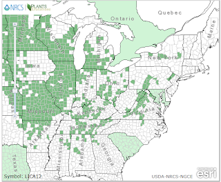
Distribution Maps (County-level)
from https://plants.usda.gov


Hairy Puccoon  (Lithospermum caroliniense) (top) has widely disjunct northern and southern populations, with an extreme outlier in southeastern Virginia.


Hoary Puccoon (Lithospermum canescens)  (bottom) is strongly centered in the midwestern U.S., gradually dribbling into reasonably adjacent areas of the southeastern U.S


Although apparently closely related "cousins" (Cohen, Cladistics 2011) these species rarely overlap except in parts of the midwestern U.S.  L. caroliniense is largely restricted to deep sandy soils. The outlier population in southeastern Virginia is found in historic longleaf pine savanna habitat (see image below), superficially similar to many of the sites for this species in the West Gulf Coastal Plain, East Gulf Coastal Plain of Florida & Alabama, and portions of Florida & South Carolina. 

Lithospermum caroliniense in longleaf pine habitat, Sussex Co, VA
Some of the northern populations of Hairy Puccoon are found in the dry, sandy "oak openings" region of Ohio, Michigan, and Indiana along with species such as Sundial Lupine (Lupinus perennis).  
Lithospermum caroliniense in Black Oak sand barren habitat, northwestern Ohio
Hoary Puccoon occurs a wide range of habitats, and a larger range of soil textures. An example includes heavy "vertic" clay derived from diabase rocks in the Piedmont region of the Mid-Atlantic.
Lithospermum canescens in central Piedmont Diabase Woodland, Durham County, NC, with Clematis ochroleuca a Mid-Atlantic endemic 

Both Lithospermum species produce distylous flowers, with two morphological variations potentially present in a given population. These "different forms of flowers on plants of the same species" (to copy the title of Charles Darwin's 1877 work) may ultimately affect the reproductive potential of both the individual and the population as a whole. These flower morphological types, essentially alternate arrangements of the anthers and stigma, can be seen in the the following examples of  L. canescens.  The uppermost image has "pin" or 'pin-eyed" flowers (stigma elevated above the anthers, which are not visible) while the lowermost has "thrum" flowers (anthers elevated above stigma which is not visible). Theoretically, this pattern should help ensure cross pollination and minimize self-fertilization. McCall (American Journal of Botany, 1996) indicates that little to no seed production occurs when distylous flowers are either self  pollinated or crossed with flowers of the same morph.

Pin flowers in Lithospermum canescens, Durham County, NC

Thrum flowers in Lithospermum canescens, Durham County, NC

This suggests the importance of a morphologically balanced population, consisting of relatively equal numbers of  pin and thrum flowers, to maintain successful reproduction. 

Molano-Flores (Proc. 17th Annual Prairie Conference, 2001) recognized the potential importance of the proportion of flower morphs and examined 17 different L. canescens populations in Illinois. In general, she found many skewed population ratios but also some with equal proportions; importantly she noted differences between "restored" and natural populations.

As suggested above, if one flower morph is disproportionately represented the result may well be low or no seed set. Molano-Flores suggest this problem can be compounded when populations are especially small and/or isolated.


Lithospermum canescens seedling; Granville County, NC
(this population supports approximately 50 individuals at last count)

Given the overall distribution maps (presented above) coupled with  localized patterns of habitat fragmentation, it is entirely possible this phenomenon could suggest a threat to remaining populations of both Lithospermum species.  Interestingly, Kirster & Levin (Genetics, 1968) inferred that colonies of L. caroliniense are highly inbred and exhibit pronounced gene flow restriction. Levin (American Journal of Botany, 1972) found a higher proportion of thrum flowers and overall low levels of seed production, minimal self-fertility, and minimal compatibility between pins and thrums. Weller (American Journal of Botany, 1980) showed that L. caroliniense has both an inefficient pollination system and intrinsically low fecundity. McCall (American Journal of Botany 1996) found that pins produced somewhat more flowers and fruits than thrums, but that thrums were slightly more common in the population of L. caroliniense she studied. 


Monarch feeding on Hoary Puccoon

How viable are the remaining, isolated populations?  Cross pollination appears to be important but Kirster & Levin (Genetics, 1968) found that pollinators (both bumblebees and Lepidopterans) rarely moved more than 10 meters from a given plant!

Given this observation and the apparent low reproduction reported by several authors it is probably especially important that at least one of the species, L. caroliniense, can live as long as suggested by Weller (Ecological Monographs, 1985).

Hmm?


Wednesday, May 16, 2018

A most marked new plant & reverse nyctinasty?


Kate's Mountain Clover (Trifolium virginicum) with inflorescence and  horizontal leaves in shaded portion of shale barren
Douthat State Park, VA (May 13, 2018)


Kate's Mountain Clover (Trifolium virginicum) was first discovered during a plant collecting trip to "southwestern Virginia" by famed botanist J.K Small in 1892.  Observed on the rocky slopes of Kate's Mountain, Greenbrier County, West Virginia, Small's published account (1893, Memoirs of the Torrey Botanical Club) indicated this species to be "the most marked new plant collected on the expedition", and distinct from all other eastern American species.  Today, we recognize the global range of Kate's Mountain Clover extending across the Valley & Ridge region of VA, WV, MD, and PA as shown on the map below.

Trifolium virginicum range,
https://plants.usda.gov/core/profile?symbol=TRVI3

A 1908 botanical monograph on North American Clovers by McDermott lumped Small's Clover with Trifolium reflexum and suggested that the species was "abundant throughout the Appalachian Mountains".  Small's opinion on this treatment was documented by Hunnewell in a brief note entitled, "A new station for three local Appalachian Plants" (Rhodora, 1923). Small was quoted as follows, "to say that the species is common in the Appalachian Mountains, may be prophecy, but such a statement certainly cannot be backed by good evidence".

Prophetic or not, many botanists have focused their attention on Trifolium virginicum since then. At one time or another, all Natural Heritage Programs within the natural range have tracked the species. Collectively, the species has been assigned a "G3 or vulnerable" rank by NatureServe. The West Virginia Native Plant Society is justifiably proud of both the plant and its discovery and has adopted the species as their official symbol. Kate's Mountain Clover has also been considered the "flagship species of the shale barrens" (Maryland Botanical Heritage Working Group, 2014).

Shale Barren habitat @ Douthat State Park, VA

Although Small did not refer to the habitat for his collection as a "shale barren" (the term did not come into common usage until approximately 1911), there are well known shale barrens on Kate's Mountain and some authors have indicated Trifolium virginicum as a shale barren endemic (Braunschweig, Nilsen & Wiebolt 1999).  The species has since been rarely encountered on related habitats, but is still most often associated with shale barrens (see http://vaplantatlas.org/index.php?do=plant&plant=3623). 

The typical shale barren habitat is a harsh environment for plant growth. The surface is often unstable with loose rock fragments and minimal soil development & the typically steep slopes tend to shed any litter accumulation down slope where it accumulates at the toe slopes (See images below).

Shale barren fractured rock surface consisting of thousands of "channers"

Toe slope of shale barren/woodland;
green line roughly indicates boundary of litter accumulation  


According to Braunschweig, Nilsen & Wiebolt (1999), surface soil temperatures and high solar irradiance distinguish shale barrens from non-shale barren sites. It has been suggested that air temperatures on the barrens are comparable to the desert regions of North America and several sources indicate soil surface temperatures at shale barrens throughout the mid-Appalachians routinely reach 50-60 degrees Celsius, or 120 degrees Farenheit.

However, such conditions do not prelude seedlings from establishing. I noticed many areas of exposed channery literally carpeted with seedlings (see image below), although I fully expect most of these seedlings to eventually succumb thereby maintaining the relatively open aspect typical of share barrens.
Exposed shale surface with abundant seedlings

What allows a species like Trifolium virginicum to adapt to the harsh environmental conditions of shale barrens?  Apparently noone really knows!  However, Clovers (Trifolium spp.) are generally known to exhibit "nyctinasty", a fancy word for plant movement caused by a stimulus, and others think of this as "sleep movement."  J. W. Harshberger devoted at least 15 years to the study of clovers and devised a contraption to measure the nyctinastic movements of various species (He published his work in the Proceedings of the American Philosophical Society, 1922). Charles Darwin also studied this phenomenon and wrote an entire book entitled "Power of Movement in Plants" in which he detailed many examples of nyctinasty. A classic example of this movement would be drooping leaves in the evening that open again in the morning, presumably to capture sunlight. However, Trifolium growing in extreme situations of high irradiance and surface temperature may need to do the opposite.  Widening and unfurling leaflets in midday would expose them to potentially dangerous heat levels. Compare the image at the top of this post taken mere moments before the image below. The former plant occurred in a patch of shade and had fully unfurled leaves/leaflets; the plant below shows vertically upright leaves in a sunnier and much hotter location.

Kate's Mountain Clover (Trifolium virginicumwith inflorescence and mostly vertical leaves in open shale barren
Douthat State Park, Bath County, VA (May 13, 2018)

I've got to go back to do more field research!


View from shale barren@Douthat State Park